
 Junio
The foundations went in three weeks ago, the steelwork is due next month, and the people funding the job keep asking the same question: how is it going? Ground-level snaps and long email updates only go so far. Anyone who has tried to explain a half-built site to a client who lives two hundred miles away knows how quickly a progress report turns into a guessing game.
The Trouble with Ground-Level Reporting
Photos taken from a site cabin or a walkway show one corner of a project at a time. They are useful for checking a specific detail, but they rarely show how deliveries, access roads, storage areas and the structure itself relate to each other. A manager may know that scaffolding is half erected on the north side, yet a director reading the report cannot picture it. That gap breeds extra phone calls, site visits and the occasional misunderstanding about what has actually been finished.
What a View from Above Adds
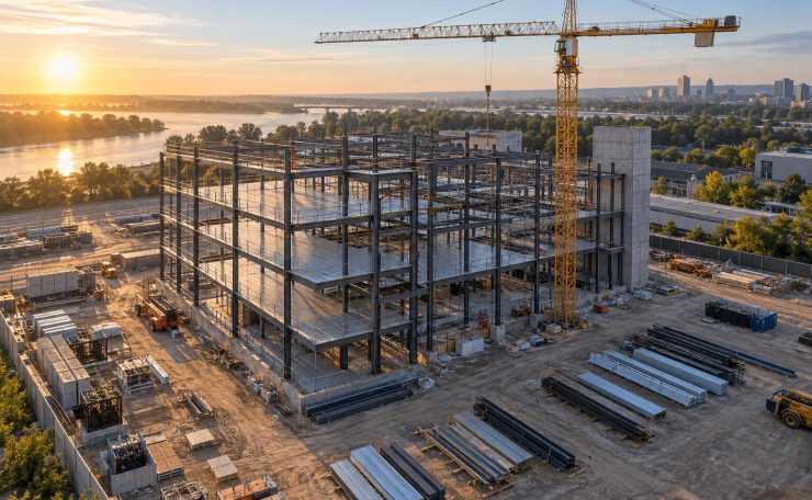
Height changes the picture. From the air, a whole footprint fits in one frame, so you can see how far the groundworks have travelled, whether the crane has room to swing and where materials are piling up. Many project teams now commission construction aerial photography at set stages, such as completion of the slab, the frame, the roof and the external works, so that each set of images can be placed beside the last. Put in a row, those pictures make progress obvious in seconds, and they settle arguments about sequence far more kindly than memory does. A funder who would never read a fortnightly programme update will happily glance at a single overhead image and see that the roof is on.
Getting Consistent, Useful Images
A single dramatic shot looks good in a brochure but does little for project control. What matters is repeatability. Ask for photographs from the same positions and heights each visit, taken at a similar time of day so shadows do not hide detail. Agree the schedule early and tie it to milestones in the programme, not to the calendar alone. Check that files arrive in a format your team can open, labelled with the date and the location of each view, because an unlabelled folder of two hundred pictures is a chore nobody enjoys.
Safety, Permissions and Practicalities
Flying over a working site is regulated, and rightly so. In the UK, operators of camera drones need the relevant registration and pilot competence, and the airspace around the site may carry restrictions. A reputable provider will check these in advance and carry appropriate insurance. On the site itself, plan around crane movements, live plant and neighbours. Let the site manager know when the flight is happening, keep people clear of the take-off area and tell the occupants of nearby buildings if anything will pass over their land.
Making the Pictures Earn Their Keep
Once the images exist, use them. Drop them into monthly reports so non-technical readers can follow along. Compare planned and actual progress without arguing over spreadsheets. Add a short caption to each image describing what changed since the last visit, so the story survives even if the original team moves on. Keep an archive, because years later, when someone needs to know exactly where a drain run or a boundary sat before the landscaping went in, those dated overhead shots can save a lot of digging.
Good communication on a build is mostly about helping people see what you can see. A regular bird’s-eye record is a simple way to do that, and it keeps conversations focused on decisions instead of descriptions. The cost is small compared with a single avoidable delay, and the habit pays back every month the job runs.